How to use GPS location in filename
Case: Use GPS based tags to add location information describing where the picture was taken
Advanced Renamer supports GPS-based tags that allow you to rename files using location information embedded in photo metadata. This is especially useful for organizing photos based on where they were taken.
Many modern cameras and smartphones embed GPS coordinates (latitude and longitude) in the EXIF metadata of image files. Advanced Renamer can convert these coordinates into human-readable location names using tags such as:
<GPS Lat> - The GPS latitude coordinate<GPS Lng> - The GPS longitude coordinate<GPS City> - The city or town where the photo was taken<GPS Country> - The country name<GPS State> - The state or region (where available)This is how you add GPS location information to your file names:
- Add the files to the list. The files must have GPS information embedded. This is often the case for photos and videos taken from a smartphone.
- If there are methods in the method list click the Clear Methods toolbar button.
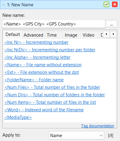
- Add the New Name method and configure it like this:
- New name:
<Name> <GPS City> <GPS Country> - Apply To: Name
- Verify the names in the list and click Start Batch.
The GPS tags will extract the location information from the metadata and rename your files accordingly. If the GPS data is not available in the files, the tags will return empty values, and those parts of the name will be omitted. Advanced Renamer uses an online database to convert GPS coordinates into human-readable names.
If this doesn't work, make sure your image or video files have proper GPS metadata embedded. You can check this by using the item details panel and look for fields like "GPS Latitude" and "GPS Longitude". If these fields are not present, the files may not have GPS data available.
Also make sure you are connected to the internet and that Advanced Renamer isn't blocked by a firewall.